Saturday, June 4, 2016

Day 7: Canyons, More Travel Issues

Yesterday was another day for sightseeing - but while the trip may be drawing to a close, it looks like I might get an unwanted extra night or two in OKC or Houston.

On Friday, the atmosphere was again lacking the necessary instability or shear for severe weather. From Roswell, we headed northeast to Amarillo to take in the sights of Palo Duro Canyon.

The second-largest canyon in the US didn't disappoint. Though many of the trails were closed due to recent rainfall (part of the same system that may delay my return to FL.. more on that in a second) breathtaking views were possible from pretty much every point on the main roads, where over 1000 feet separated the canyon floor and the observer near the top.

With all the vegetation, it may not look as impressive as the more barren Grand Canyon, but many features of the landscape lent Palo Duro a unique charm.
The view from the bottom was just as cool!
A short drive down a narrow road full of switchbacks led to the bottom. I was amazed at the number of places where you were able to just get out and explore. Another cool feature was the thin, red-tinted soil covering everything - it stained your hands to touch the stuff.  Just like as in Carlsbad Caverns yesterday, it was hard to believe I was still on the same planet considering the vast, nearly featureless landscape surrounding this place!

Today is the last full (scheduled) day of the trip. We're driving the 3 and 1/2 hours to OKC, and set to observe the Alfred Murrah building memorial.
 
I have no idea when I'll get home.

Heavy rains have flooded much of east Texas over the past few days, with 8 - 10" of rain having fallen in some spots! I am scheduled to fly through Houston on my way home to Tampa, which, yes, by the way, is squarely in the path of a developing tropical wave. So between the multitude of weather delays currently in Houston and the many delays likely to impact Tampa, I put my odds of getting home on Sunday at an optimistic 50/50. 

That's for another day, though. I'll update you tomorrow with the latest!

Friday, June 3, 2016

Day 6: Caves and UFOs

After an extraordinary 3 days of weather, it was time to check out the extraterrestrials.

We stayed the night in the small town of Fort Stockton in the far west of Texas. It was the type of place where nearly vehicle was a truck and there were Mexican restaurants on every other corner - good ones.

The morning guidance did not look promising. A cutoff low was stuck over east Texas dumping copious amounts of rain, but very few storms were to be strong. In fact, the low was wrapping in dry air on its backside that was likely to limit instability in our area, and to top it all off a cold front had pushed through the area.

We decided that sightseeing would prove more beneficial than chasing, so we headed back west to New Mexico.

The first stop were the Carlsbad Caverns. Pictures really don't do this place justice. The cave is MASSIVE - and the entrance is dramatic. You first drive on a winding mountain road, gaining over 1,000 feet in elevation up a series of windblown switchbacks. The view from the top of the caves provides a vantage with visibility of well over 100 miles in any direction.

The descent into the cave is a 1.2 mile half-tunnel, half-trail where you drop over 750 feet. Not for the faint of heart nor weak of legs!

That winding gray is the path down into the caverns. Birds were flying in and out of the cave, providing the only sounds.

Stepping off the path? Not a good idea. A 200 foot drop awaited at the aptly named "Bottomless Pit". Ladders from expeditions in the 1920s and 1930s still hung in some spots, untouched for nearly 100 years.
They call this Nipple Rock. No idea why...
My first national park experience was an amazing, peaceful one. A steal for only $10 admission fee, I highly recommend it! A member of our group who lives near Mammoth Cave said it puts that place to shame. If you think caves are creepy, smelly and full of bats, this will definitely change your perception. (The entrance smelled like a pet store, other than that it was fairly subdued.)

After a few hours there, we headed to our second and final stop in Roswell, NM. Being a bit of an ET buff I was excited to see all the kitschy alien stuff, and it didn't disappoint. Everywhere from the credit union to the gas station had little green aliens out front, although it wasn't quite as pronounced as it could've been.

A typical street corner in Roswell.
Today once again looks quite boring near us weather-wise. With the trip's unofficial end looming tomorrow evening, we've pretty much seen all we're going to see. We're headed for a second day of sightseeing, to the nation's second-biggest canyon - Palo Duro Canyon near Amarillo. We'll stay the night there before driving back into OKC tomorrow. I'm scheduled to fly to Tampa via Houston on Sunday so I'm hoping the flood waters subside a bit - I only have 55 minutes to make my connecting flight!

Oh yeah, and this.

Wednesday, June 1, 2016

Day 5: The largest hail in the country, 3 supercells, Mexico

I want to start off this post with a big thank you to everyone who has reached out to me over the last few days! I appreciate everyone who is reading this blog, and if you have any comments, questions, or suggestions I welcome any and all input.

If you had told me last night that today would end up being the craziest day yet of the chase, I would tell you flatly: no way.

If you had told me that despite only a Marginal risk from the SPC, I would end up seeing tennis-ball sized hail (largest in the country today), rare mammatus clouds so pronounced that our professor called them "as good as they come", and that I would sit through a violent hailstorm watching quarter-sized hail shatter against the window amidst hurricane-force winds less than a foot away from me, I would have said you were crazy.

(Yeah, yeah, yeah, you say... PICS OR IT DIDN'T HAPPEN!)
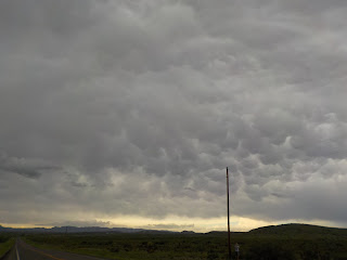
Mammatus clouds in a storm near Fort Davis.
We started the day in Midland, near where the center of action would likely be. Model data from the HRRR showed lively pulse storms spawning in a similar location to the last two days, with the added possible benefit of a cold front approaching from the north. Surface observations showed a distinct moisture gradient with much drier conditions near Carlsbad in SE New Mexico to unusually juicy air in Del Rio, east along the Rio Grande. With this in mind, we headed south to the high desert near the Mexican Border.

After eating lunch in the charming town of Fort Stockton, we headed even further west toward Balmorhea. I know this is a cliche - but it's hard to fathom how vast Texas really is until you spend 4 days driving around and don't see the same place twice. Seeing a cell crop up among the peaks to our south, we turned toward the mountains on the twisting road to Fort Davis.

It was a ride I will not soon forget. The combination of dramatic mesas, the Davis Mountains rising over 1,000 feet above either side of the road, and the heavy storms made the drive truly surreal. The landscape is rugged beauty personified.

I took the above picture of the mammatus around that time. We drove straight into the belly of a storm while on that winding road. I was initially confused: we were nearing 5,000 feet altitude, and I saw white covering much of the ground. Could there still be snow here?  No - it was hail -  so much that the road was layered an inch thick. A fog rose above the surrounding grass where the subliming hail cooled the air. I felt like I was in Middle Earth.
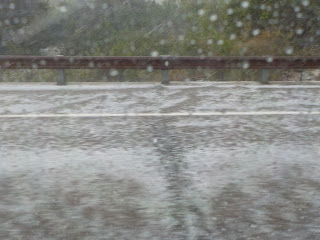
Hail blanketing the ground between Fort Davis and Alpine.
But the hailstorms were only just beginning. As impressive as this was, we saw a much more powerful storm working its way east on US 90 about 80 miles down the road. 70 dBZ tops! 60 mph inflow! But would it hold together? We headed that way.

An hour later, I could not believe my eyes. Massive hail stones 2" in diameter littered the roadway and hillsides! We had just come across a massive storm that had no signs of weakening, heading perfectly down the area's major road. Our luck was incredible, even if the cell reception was decidedly less so!
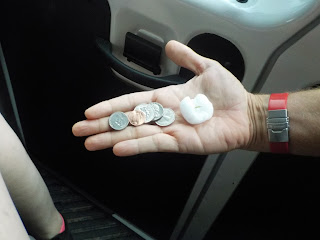
1.5-2" hail in the Sanderson, TX supercell.
With almost no radar coverage (the nearest radar was 130 miles away) and with cell service virtually non-existent, we had to rely on our cloud-spotting abilities and a bit of luck to get in position. Getting intermittent scans on my phone, we turned a corner toward where the hail should have been, and my jaw dropped.

Hail the size of pool balls and tennis balls was scattered along the roads and in the ditches. The few cars there were pulled over under cover with wipers waving furiously and emergency lights on. We hopped out and grabbed some stones. Never again do I want to see hail that large unless I'm in someone else's car!
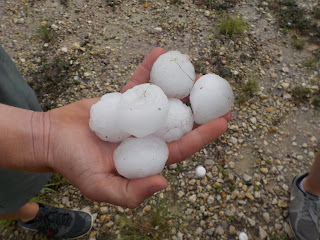
2.2.5-2.5" hail from the same Sanderson, TX storm.
The hail core seemed to have lifted north and east, so we drove another 15 miles to the next intersection (seriously) and turned north. I had a tiny bit of reception on the road north that allowed us to nudge ourselves into the path of the hail core for the first time to directly experience the hail. I'll let this video show what happened next:

https://youtu.be/Sb5WfB7doVo

It was the first time this trip that we had gotten ourselves into a severe hail core. The hail hit the van with so much power we were afraid the windows would shatter. Dr. Brown aligned the van so that we faced into the wind to give us a better view. The only thing I've seen that's comparable is Hurricane Wilma - just add hail.

It didn't last long, but it lasted long enough. By 7 pm, the storms were beginning to weaken. We re-traced our steps and caught sight of a pretty storm near the Mexican border. The clouds, especially on the right (inflow) side, glowed aquamarine with hail.

Tomorrow, the risk appears to be extremely marginal that we'll see anything severe at all - let alone anything as spectacular as we've seen the last couple days. The tentative plan is to go the Carlsbad Caverns. I'll keep you posted!

Day 4: The most beautiful storm, and a new personal dBZ record

For the third straight day, we were in West Texas; for the third straight day, despite the odds, I saw something incredible.

Early morning models showed strong storms firing well to our east (near Austin-San Antonio) with VERY juicy dewpoints of 70+ degrees F.  Tornado chances were highest to our west, though, and later in the day, so we decided early on to hang in the Midland area and wait.

Big Spring State Park, Big Spring TX.
Our stop was Big Spring State Park, where a winding two-lane road led to a stunning vista over the town of Big Spring. Thunderstorm anvils in western New Mexico were visible - over 150 miles away! From this angle, it was easy to observe an outflow boundary from strong storms to our east interact with pulse storms firing over the area. The results were dramatic, mushrooming cumulonimbus clouds rising at up to 10,000 feet per minute right in front of us!

We stayed at Big Spring for a couple hours, but after 6pm came and went we were not feeling confident. With 2 hours of daylight left, our options were limited and we decided to chase after a storm about 40 miles to our northwest.

It was the best decision of the trip.

Minutes after we got on the highway, the Midland NWS office severe warned the storms for large hail and 60 mph winds - and with good reason! The storm exploded. dBZ values exceeded 70 (a very strong hail signature), and radar indicated velocities aloft of hurricane-force!

Never before had I seen a storm this strong.
Inbound velocities of 80 mph at 4,000 feet... this storm was mean!
The best part about this storm was its amazing visual appearance (<- video linked). Even more than the storms yesterday, every part of the storm was visible. From the deep gray updraft base to the rain shaft falling thousands of feet, the angry gust front kicking up massive dust clouds to our left to the dramatic anvil overhead - it was all there. To top it all off, the storm occurred during sunset, dramatically casting the entire thing in an amber glow. If it weren't for the lightning cracking within half a mile on all sides of us, I might have called the entire scene peaceful.

The dramatic storm near Ackerly, TX at maturity.
The sun was setting though, and the greatness couldn't last. Severe storms just to our northwest were putting out some impressive wind and hail estimates as they rode an outflow boundary into Odessa around 11pm, lightning the night sky at the hotel in Midland.

We're headed toward the Mexican border today in hope of some hail-producing supercells!

Monday, May 30, 2016

Day 3: Extreme close-up of a rotating wall cloud, my 30th state, and 7 pics of lightning

After the disappointment yesterday, today started with a similar atmospheric profile. The mood was glum and we were restless. We knew that conditions were only marginally favorable for severe weather development in our neck of the woods.

We headed west from Brownfield, TX as thunderstorms began to fire in the mountains of eastern New Mexico. I had never been to New Mexico and being a geography nerd, was very excited to get my 30th state! We stopped in Dobbs and then the waiting game began.

The Land of Enchantment was relatively unenchanting with regards to severe weather.
Around 1pm, Dr. Brown decided to launch a weather balloon to get a feel for the atmospheric setup near us (the nearest radar sites are over 100 miles away). It was only my 2nd time ever observing a sounding launch, and the first time I've gotten to hold the equipment. Results? The atmosphere was very dry in the lower levels and only slightly better aloft. It was time to head back east - but where?

Me and the weather balloon! It's amazing that what looks like a party balloon and a styrofoam cup can tell you tons about the atmosphere.
Storms were firing about 100 miles to our east in Midland, but they appeared to be fizzling. The SPC highlighted an area close to the Mexican border about 150 miles south, and we initially headed that way - but something caught our eye unexpectedly on radar. It was a pulse thunderstorm about 40 miles east of Midland appearing to interact with an outflow boundary... the same one we drove over last night.

Bingo.

There were no other chasers in the area - they all went south -  and the roads were clear. The storms exploded in the course of 30 minutes, and by the time we got there a severe t-storm warning was issued as the updrafts soared 10 miles into the sky! I happened to get my first picture of lightning on the approach - the first of SEVEN separate bolts I got on camera.

Looking into the heart of the severe t-storm near Big Spring, TX. My first shot of lightning!
We got perfectly into position on the storm's southern flank and stopped to watch the show. Radar-indicated velocities showed a mesocyclone beginning to form, and the storm quickly began to take on the classic kidney bean shape of a supercell. Wind speeds in the storm reached to near hurricane-force. A hook echo dropped off the backside of the storm and the storm's motion went to a near stand-still right in front of us. We were no more than 4 miles away! Winds were whipping at 15-20 sustained with much higher gusts, kicking up sand and pressing plants flat to the ground.

And then it happened: we saw a wall cloud begin to drop down, along with a funnel-shaped area of rotation. A tornado was trying to form less than 5 miles away! It sent chills up my spine and even knowing the proximity and power of this beast, I felt nothing but awe as the sky swirled above me.

The radar picture as I looked into a hook echo from ~3-4 miles away. You can make out my location on my cell phone screen as the blue circle, and the blue triangle is the direction I'm looking.
Sadly, the rear flank downdraft pulled in much colder air, and thus no tornado could form. The storm occluded, bringing the hook echo back into the storm and the updraft gradually weakened. Nonetheless, it was an incredible show - one that I will never forget. We headed to the hotel in high spirits, all uniformly spellbound.

We're rooming tonight in Big Spring, and conditions are looking favorable again for similar action tomorrow. At this point, anything is gravy. This Earth is an amazing, beautiful thing, and I am lucky to be alive to witness nature's greatness.

Sunday, May 29, 2016

Day 2: 715 miles, my first mammatus clouds, and the smallest county in the US

Today was a roller coaster!

The day began with some optimism after the Storm Prediction Center upgraded the severe risk to Enhanced from Slight. Significant hail, damaging winds and some tornadoes were expected to pop over west Texas, far eastern New Mexico and perhaps a storm or two over western Oklahoma. Energy Helicity Indices were looking good, Lifted Index numbers were in the -10 to -11C range, CAPE was projected at over 5000 in the Midland area, and a dryline was moving eastward toward Carlsbad... it seemed too good to be true.

Since it was 511 miles to Midland from our base in OKC, we left early. Making good time on the fast and sparsely trafficked freeways, we were positioned in Odessa by 2pm.

The entire crew! Can you tell the winds were starting to pick up?
Storms were firing nicely along the dryline in eastern New Mexico, producing the first of over 200 damage reports today - but were moving at a snail's pace - even the severe-warned storms were moving at a scant 10-15 mph, and a stubborn inversion between 850-925mb remained in place as of the 18z sounding. At this point, our options were limited to another 4 hours headed back north in an attempt to catch some stronger stuff firing near the OK/TX border, or heading further west toward the NM storms.

Hoping to catch the dryline action, we went west.

My excitement grew as we neared a place on the map that has fascinated me for years - Loving County, TX. Less than 100 people live in the 670 square miles of arid, forsaken plateau just south of New Mexico and 75 miles west of Odessa. Stop lights? Yeah right. We traveled over 20 miles without seeing a house -  let alone a gas station, restaurant, or hospital. It was the least populous county in the United States as of the 2010 Census.

Dr. Brown was gracious enough to stop the van so I could get a picture at the county line! I'm standing on a pile of used tires (???) that were stacked to the right of the sign. For good measure, a severe thunderstorm is photobombing about 40 miles behind me!
As I was posing with the sign, I heard, "look!" We were nearing the outflow from a severe-warned thunderstorm to the west, and in the blowoff to our south were my first-ever mammatus clouds! This was, to put it mildly, breathtaking.
Mammatus clouds over Loving County, TX.
It was becoming clear that the dryline wasn't budging, though, and that meant the lifting mechanisms were not there to support continued strong convection. We circled back around to Midland, but skies were clearing and there was almost nothing on radar within 150 miles - essentially the entire area the SPC warned for an enhanced risk

We decided to call it a night, heading north with some disappointment to Brownfield, TX.

The story's not over yet, though. About 50 miles north of Midland we caught a wicked outflow boundary booking south at 35 or 40 mph from a complex of storms near the OK/TX border. It was just after sunset, and suddenly our van was hit with a violent shock while visibility instantly dropped to less than a quarter mile. Dust choked the air and wind gusts howled to what must have been at least 50mph! The van rattled and groaned as the wind shrieked by us in the pitch dark for the next 50 miles. What an ending.

Tomorrow things look just as iffy as today. We're positioned in a large area of Slight risk according to the SPC. We'll be on the road by 9am looking for trouble!

Good night from west Texas!

Saturday, May 28, 2016

Day 1: Chasing Planes, and a Couple Storms

There is absolutely no work or business-related text message ANYONE wants to get at 2AM. Especially when that message informs you that your flight was delayed by 2 hours, and that you will miss your connecting flight due to the resulting delay. Your flight you were waking up for in two hours.

So began the saga of my 14-hour-airport day.

Instead of flying the sensible Tampa-Houston-OKC route, my only option was to be transferred on an unlikely vector through Chicago, bumped from first class (no refund) and delayed by five hours. My route was the airline equivalent of a Rube Goldberg machine.

Whoever invented this in-flight telemetry thing is my person. I was probably the only one on board watching mainly to see where the LCL and freezing layers were, though.

But was it ordained?

Just as with my NOLA/Austin drive (I discuss that in my previous post) I again felt the weather wanted me to get closer by some trick of fate. Less than an hour after my flight was re-routed, a Severe Thunderstorm Watch was posted for southern Iowa and northwest Illinois. Our flight would have to avoid the Mesoscale Convective System on its way to OKC.

If the severe turbulence on our 60-seat plane was any evidence, our pilot did a less-than-stellar job of doing that. At least I got some cool pictures in between trying not to squeal.

It's hard to see, but that's an impressive cumulonimbus anvil rising in the background ahead of a scattered (and much lower altitude) cumulus deck. Around this time the plane was shaking like a cold chihuahua.
After encountering two of my fellow chasers at the airport by chance, we met the rest of the group and gathered at our hotel. Our first day of chasing is tomorrow, likely to West Texas where we'll likely see some big hail... and with any luck, a tornado or two!

An overshooting top is visible near the wing's edge, probably 50 miles away. This complex of storms was being warned for severe thunderstorms at the time, and an overshooting top is indicative of a powerful updraft (and strong storm)